Home > Arts > Artists > R > Roman Roman
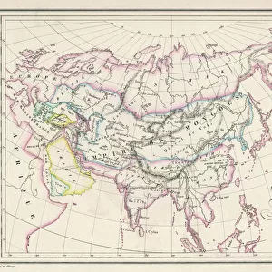
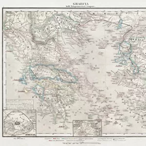
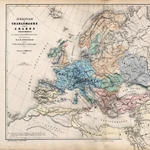
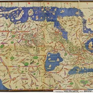
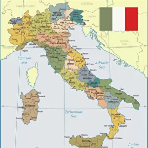
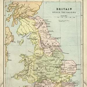
Gaul in the time of Julius Caesar, published in 1867

![]()
Wall Art and Photo Gifts from Fine Art Storehouse
Gaul in the time of Julius Caesar, published in 1867
Gaul in the time of Roman politican Gaius Iulius Caesar (100 - 44 BC). Steel engraving with hand-colored borderlines and Latin legend, published in 1867
Unleash your creativity and transform your space into a visual masterpiece!
Media ID 13667223
© ZU_09
1st Century Bc Ancient History Ancient Rome Aquitaine Belgium Benelux Britannia British Culture Contour Drawing Ethnocultural History European Culture French Culture Julius Caesar Emperor Roman Steel Engraving Topographic Map Topography Caligula Gaul Obsolete Roman Republic
FEATURES IN THESE COLLECTIONS
> Arts
> Artists
> R
> Roman Roman
> Europe
> Belgium
> Related Images
> Europe
> Germany
> Related Images
> Europe
> Italy
> Lazio
> Rome
> Fine Art Storehouse
> Legends and Icons
> Famous Military Leaders
> Julius Caesar (100 BC-44 BC)
> Fine Art Storehouse
> Map
> Historical Maps
> Fine Art Storehouse
> Map
> Italian Maps
EDITORS COMMENTS
This print takes us back to the ancient world, specifically Gaul during the time of Julius Caesar. Published in 1867, this steel engraving with hand-colored borderlines and Latin legend beautifully captures the essence of Roman politician Gaius Iulius Caesar's era (100 - 44 BC). The image showcases a meticulously detailed map that provides an invaluable glimpse into European culture and ancient history. As we explore this antique piece, we are transported to a bygone era where civilizations flourished and empires rose and fell. With its engraved contours and topographic precision, this etching offers a comprehensive view of Gaul's landscape during the first century BC. From Britannia to Italy, Germany to Belgium, Benelux to Aquitaine, every region is intricately depicted on this historical artifact. As we delve deeper into the details of this illustration, it becomes evident that it serves as more than just a geographical representation. It symbolizes the rich tapestry of human existence: conquests made by Julius Caesar himself; cultural exchanges between French and British societies; capital cities bustling with life; ethnocultural histories interwoven across Europe. Though considered obsolete in terms of modern cartography techniques, this print remains an invaluable resource for historians and enthusiasts alike. It allows us to reflect upon our past while appreciating how far we have come as a civilization. Let us cherish these remnants from antiquity as they provide glimpses into worlds long gone but not forgotten.
MADE IN THE USA
Safe Shipping with 30 Day Money Back Guarantee
FREE PERSONALISATION*
We are proud to offer a range of customisation features including Personalised Captions, Color Filters and Picture Zoom Tools
SECURE PAYMENTS
We happily accept a wide range of payment options so you can pay for the things you need in the way that is most convenient for you
* Options may vary by product and licensing agreement. Zoomed Pictures can be adjusted in the Cart.