Home > Fine Art Storehouse > Map
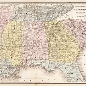
Victorian Map of North America

![]()
Wall Art and Photo Gifts from Fine Art Storehouse
Victorian Map of North America
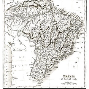
Engraved illustrations of the Physical Map of South America from Iconographic Encyclopedia of Science, Literature and Art, Published in 1851. Copyright has expired on this artwork. Digitally restored
Unleash your creativity and transform your space into a visual masterpiece!
bauhaus1000
Media ID 13666971
© Craig McCausland
1850 1859 Argentina Brazil Chart Chile Country Geographic Area Diagram Drypoint Ecuador Image Created 1850 1859 Isolated Isolated On White Peru Plan South America Steel Engraving The Americas World Map Drawing Art Product Image Created 19th Century
FEATURES IN THESE COLLECTIONS
> Fine Art Storehouse
> Map
> Historical Maps
EDITORS COMMENTS
This print takes us back to the 19th century, immersing us in the rich history of cartography and travel. The Victorian Map of North America is a true masterpiece, showcasing engraved illustrations that were originally featured in the Iconographic Encyclopedia of Science, Literature and Art published in 1851. With its intricate details and exquisite craftsmanship, this digitally restored artwork transports us to a time when exploration was at its peak. The woodcut style adds a touch of authenticity, while the drypoint engraving technique brings out every contour and feature with remarkable precision. As we gaze upon this image created over 150 years ago, we are reminded of the vastness and diversity of South America. From Peru to Chile, Brazil to Ecuador, Argentina to other countries within this geographic area – each one meticulously depicted on this steel engraving. Isolated on a white background, this print allows us to focus solely on the beauty and artistry it holds. It serves as both an educational tool for studying physical geography and as an aesthetic delight for those who appreciate vintage illustrations. A true testament to human curiosity and artistic skill from another era, this Victorian Map invites us into a world where maps were not just practical tools but also works of art. Let it transport you back in time as you explore the wonders that lie within its borders.
MADE IN THE USA
Safe Shipping with 30 Day Money Back Guarantee
FREE PERSONALISATION*
We are proud to offer a range of customisation features including Personalised Captions, Color Filters and Picture Zoom Tools
SECURE PAYMENTS
We happily accept a wide range of payment options so you can pay for the things you need in the way that is most convenient for you
* Options may vary by product and licensing agreement. Zoomed Pictures can be adjusted in the Cart.