Home > Science > Space Exploration > Satellite Imagery
Dry river beds, satellite image

![]()
Wall Art and Photo Gifts from Science Photo Library
Dry river beds, satellite image
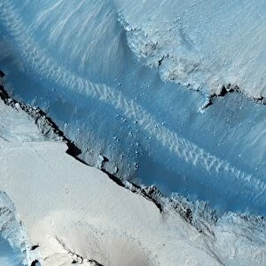
Dry river beds, satellite image. North is at top. The bright blue areas are meandering wadis (dry river beds) that have formed in this desert area due to flooding. Desert areas can go for years without rain, and then be flooded by large storms. The floodwaters briefly carve patterns in the landscape and then evaporate or sink into the soil. The bright blue areas have higher moisture content than the surrounding areas. This area is in eastern Jordan, near the Syrian border. The area shown in this image is around 60 kilometres wide. The image data includes infrared wavelengths, and was obtained on 17 May 2001, using the ASTER sensor on the Terra satellite
Science Photo Library features Science and Medical images including photos and illustrations
Media ID 6357889
© NASA/SCIENCE PHOTO LIBRARY
2000s 2001 Advanced Spaceborne Arid Aster Desert Earth Observation Earth Science From Space Hydrology Infra Red Jordan Land Middle East Physical Geography Reflection Radiometer Riverine Rocky Sandy Satellite Satellite Image Terra Thermal Emission And Jordanian Wadi
FEATURES IN THESE COLLECTIONS
> Science Photo Library
> Aerial and Satellite
> Science Photo Library
> Graphics and Patterns
> Science
> Space Exploration
> Satellite Imagery
EDITORS COMMENTS
This satellite image captures the intricate beauty of dry river beds in a desert area near the Syrian border in eastern Jordan. The top of the photo represents north, and the bright blue areas depict meandering wadis, or dry river beds that have formed due to occasional flooding. In these arid regions, years can pass without rainfall until sudden large storms transform the landscape into temporary waterways. The floodwaters swiftly carve mesmerizing patterns before either evaporating or seeping into the parched soil. The distinct brightness of these blue areas indicates higher moisture content compared to their surroundings. This 60-kilometer-wide expanse showcases nature's resilience amidst harsh conditions as it adapts to intermittent deluges and prolonged droughts. The photograph was taken on May 17,2001, using infrared wavelengths by ASTER sensor aboard Terra satellite. This remarkable snapshot not only highlights Earth's diverse geography but also emphasizes how hydrology shapes our planet's physical features. It serves as a reminder that even seemingly lifeless deserts possess hidden wonders waiting to be discovered from space through advanced technology like satellites equipped with thermal emission and reflection radiometers. Science Photo Library presents this stunning print capturing an extraordinary moment frozen in time—a testament to both the power of nature and humanity's ability to explore and appreciate its wonders from afar.
MADE IN THE USA
Safe Shipping with 30 Day Money Back Guarantee
FREE PERSONALISATION*
We are proud to offer a range of customisation features including Personalised Captions, Color Filters and Picture Zoom Tools
SECURE PAYMENTS
We happily accept a wide range of payment options so you can pay for the things you need in the way that is most convenient for you
* Options may vary by product and licensing agreement. Zoomed Pictures can be adjusted in the Cart.