Home > Europe > United Kingdom > England > London > Towns > Farnborough
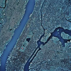
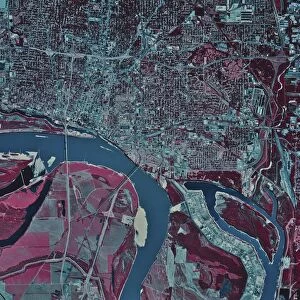
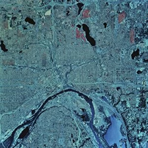
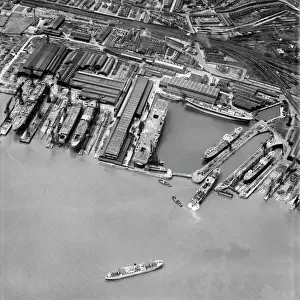
Composite Landsat false colour image of Greater London, 1979

![]()
Wall Art and Photo Gifts from Heritage Images
Composite Landsat false colour image of Greater London, 1979
Composite Landsat false colour image of Greater London, 1979. This image was processed by the Space Department at the Royal Aircraft Establishment, Farnborough, from Landsat pictures received in May 1979. The River Thames and the Serpentine can clearly be seen. Parks and other green spaces show up as bright red. Five Landsats were launched between 1972 and 1984 to study the earths surface in various spectral bands from the visible to the infrared with a resolution of about 30 metres
Heritage Images features heritage image collections
Media ID 14863515
© NASA/Oxford Science Archive / Heritage-Images
1970s Aerial View Greater London Nasa Oxford Science Archive Satellite Satellite Photography Serpentine Seventies Space Space Travel Landsat Satellite Image
FEATURES IN THESE COLLECTIONS
> Aerial Photography
> England
> Aerial Photography
> Related Images
> Europe
> United Kingdom
> England
> Aerial Views
> Europe
> United Kingdom
> England
> Greater London
> Related Images
> Europe
> United Kingdom
> England
> Lakes
> Europe
> United Kingdom
> England
> London
> River Thames
> Europe
> United Kingdom
> England
> London
> Royalty
> Europe
> United Kingdom
> England
> London
> Sights
> Green Park
> Europe
> United Kingdom
> England
> London
> Sights
> Serpentine
> Europe
> United Kingdom
> England
> London
> Towns
> Farnborough
EDITORS COMMENTS
This print showcases a composite Landsat false colour image of Greater London in 1979. Processed by the esteemed Space Department at the Royal Aircraft Establishment, Farnborough, this image was created from Landsat pictures received in May of that year. The River Thames gracefully winds its way through the city, while the Serpentine lake glistens under the sunlight. What truly stands out are the vibrant green spaces and parks scattered throughout Greater London, appearing as bright red patches on this technologically advanced aerial view. During the 1970s, NASA launched five Landsats to study Earth's surface using various spectral bands from visible to infrared with an impressive resolution of about 30 meters. This particular photograph captures a moment frozen in time—a testament to both scientific progress and artistic beauty. The composite image offers viewers a unique perspective on England's capital city during this era. It serves as a reminder of how satellite photography revolutionized geographical studies and our understanding of urban landscapes. Preserved within this print is not only an extraordinary piece of history but also an appreciation for humanity's exploration beyond our planet's boundaries. As we gaze upon this remarkable snapshot captured by an unknown creator, we are transported back to a time when technology merged with artistry to unveil new dimensions of knowledge about our world—both seen and unseen.
MADE IN THE USA
Safe Shipping with 30 Day Money Back Guarantee
FREE PERSONALISATION*
We are proud to offer a range of customisation features including Personalised Captions, Color Filters and Picture Zoom Tools
SECURE PAYMENTS
We happily accept a wide range of payment options so you can pay for the things you need in the way that is most convenient for you
* Options may vary by product and licensing agreement. Zoomed Pictures can be adjusted in the Cart.