Hawaiian Islands, 3D artwork C015 / 6568

![]()
Wall Art and Photo Gifts from Science Photo Library
Hawaiian Islands, 3D artwork C015 / 6568
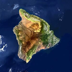
Hawaiian Islands. Simulated 3D high-altitude view of the Hawaiian Islands, viewed from the east. Image based on Landsat satellite images and detailed digital terrain data. Detailed bathymetry data reveals the topography of the sea floor, showing the Hawaiian Islands to be the tops of immense volcanic mountains rising more than 9, 000 metres from the bed of the Pacific Ocean. In the foreground is Hawaiis Big Island, with its volcanoes - Mauna Kea, Mauna Loa, and Kilauea, which is active and smoking in the foreground
Science Photo Library features Science and Medical images including photos and illustrations
Media ID 9212953
© PLANETARY VISIONS LTD/SCIENCE PHOTO LIBRARY
Active Aerial View America Big Island Chain Coast Coastal Digital Terrain Data From Space Geological Hawaii High Altitude Island Islands Kilauea Landsat Mauna Kea Mountain Mountainous Mountains Pacific Ocean Peak Peaks Physical Geography Satellite Satellite Image Simulated Simulation Volcanic Volcano Volcanoes Volcanology Volcanos Vulcanology Mauna Loa Unites States
EDITORS COMMENTS
This stunning 3D artwork print captures the breathtaking beauty of the Hawaiian Islands from a high-altitude perspective. The image, based on Landsat satellite images and detailed digital terrain data, reveals the intricate topography of both land and sea floor. As we gaze upon this masterpiece, we witness the majestic volcanic mountains that make up these islands rising over 9,000 meters from the depths of the Pacific Ocean. In the foreground lies Hawaii's Big Island, showcasing its iconic volcanoes - Mauna Kea, Mauna Loa, and Kilauea. The latter is particularly captivating as it emits smoke in an active display of nature's power. This artwork not only highlights their geological significance but also showcases their coastal charm against a backdrop of crystal-clear waters. As our eyes explore this aerial view captured by satellites in space, we are reminded of America's diverse landscapes and natural wonders. From mountainous peaks to volcanic activity that shapes these islands' very existence, this artwork encapsulates both physical geography and volcanology with remarkable detail. Created by PLANETARY VISIONS LTD/SCIENCE PHOTO LIBRARY without any commercial intent mentioned explicitly; it serves as a testament to their dedication to capturing Earth's awe-inspiring beauty through artistry and scientific precision.
MADE IN THE USA
Safe Shipping with 30 Day Money Back Guarantee
FREE PERSONALISATION*
We are proud to offer a range of customisation features including Personalised Captions, Color Filters and Picture Zoom Tools
SECURE PAYMENTS
We happily accept a wide range of payment options so you can pay for the things you need in the way that is most convenient for you
* Options may vary by product and licensing agreement. Zoomed Pictures can be adjusted in the Cart.