Home > Europe > United Kingdom > England > London > Boroughs > Ealing
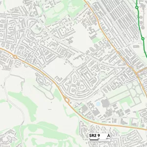
Leicester LE2 7 Map

![]()
Wall Art and Photo Gifts from Map Marketing
Leicester LE2 7 Map
Postcode Sector Map of Leicester LE2 7
Media ID 19973631
Almond Road Boundary Road Cavendish Road Clarendon Street Clifton Road Coniston Avenue Dartford Road Farndale Close Grasmere Street Grisedale Close Havelock Street Hawkins Road Hazel Street Infirmary Road Leicester Martindale Close Mill Lane New Bridge Street New Park Road Norton Street Oliver Street Pavilion Close Pelham Street Pentland Close Richmond Road Rydal Street Shakespeare Street Sheridan Street The Gateway Thyme Close Walnut Street Windermere Street Winifred Street Woodford Road Deacon Street Filbert Street
FEATURES IN THESE COLLECTIONS
> Europe
> United Kingdom
> England
> London
> Boroughs
> Ealing
> Europe
> United Kingdom
> England
> London
> Sights
> Richmond Park
> Europe
> United Kingdom
> Wales
> Powys
> Knighton
> Map Marketing
> Postcode Sector Maps
> LE - Leicester
> Maps and Charts
> Related Images
> South America
> Brazil
> Maps
> South America
> Brazil
> Related Images
MADE IN THE USA
Safe Shipping with 30 Day Money Back Guarantee
FREE PERSONALISATION*
We are proud to offer a range of customisation features including Personalised Captions, Color Filters and Picture Zoom Tools
SECURE PAYMENTS
We happily accept a wide range of payment options so you can pay for the things you need in the way that is most convenient for you
* Options may vary by product and licensing agreement. Zoomed Pictures can be adjusted in the Cart.