Home > Asia > Kazakhstan > Maps
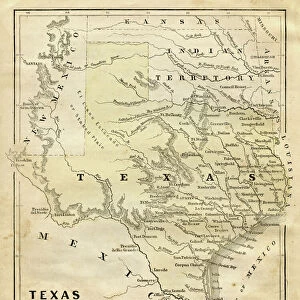
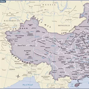
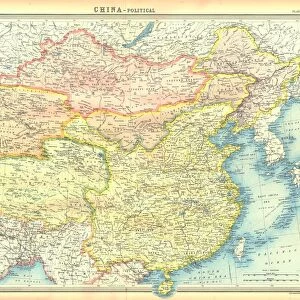
Political map of China

![]()
Wall Art and Photo Gifts from Heritage Images
Political map of China
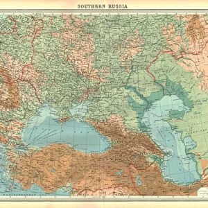
Political map of China. Map showing China, Mongolia, East Turkestan, Tibet and the Korean peninsula. Plate 62 from The Times Atlas
Heritage Images features heritage image collections
Media ID 15464450
© The Print Collector / Heritage-Images
Cartography Coastline Far East Kazakhstan Korea Map Making Mongolia South China Sea Tibet Turkestan
FEATURES IN THESE COLLECTIONS
> Asia
> Kazakhstan
> Maps
> Asia
> Kazakhstan
> Related Images
> Asia
> Mongolia
> Related Images
> Asia
> South Korea
> Maps
> Asia
> South Korea
> Related Images
> Maps and Charts
> Kazakhstan
> Maps and Charts
> Related Images
EDITORS COMMENTS
This print showcases a meticulously detailed political map of China, offering a glimpse into the vast and diverse landscape of this ancient civilization. The map encompasses not only China itself but also neighboring regions such as Mongolia, East Turkestan, Tibet, and the Korean peninsula. Plate 62 from The Times Atlas, this cartographic masterpiece is a testament to the artistry and precision involved in map-making. The vibrant colors used in this print bring out the geographical features with stunning clarity. From the rugged coastlines that hug China's eastern border to the expansive South China Sea that stretches along its southern edge, every contour is beautifully depicted. This visual representation allows us to appreciate both the immense size of China and its strategic location within East Asia. Beyond its borders lie other significant territories like Kazakhstan and Korea, which are also included on this comprehensive map. Additionally, it sheds light on lesser-known areas such as East Turkestan (now Xinjiang) and Tibet—regions with rich cultural histories that have shaped modern-day China. As we delve into this remarkable print from Heritage Images' collection, we are transported through time and space—a reminder of how maps serve as windows into our world's past while guiding us towards an understanding of our present reality. Let us marvel at this exquisite piece of cartography for its educational value rather than considering any commercial use it may hold.
MADE IN THE USA
Safe Shipping with 30 Day Money Back Guarantee
FREE PERSONALISATION*
We are proud to offer a range of customisation features including Personalised Captions, Color Filters and Picture Zoom Tools
SECURE PAYMENTS
We happily accept a wide range of payment options so you can pay for the things you need in the way that is most convenient for you
* Options may vary by product and licensing agreement. Zoomed Pictures can be adjusted in the Cart.