Home > North America > United States of America > Massachusetts > Worcester
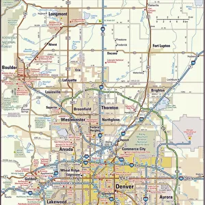
MA Worcester Lunenburg Vector Road Map

![]()
Wall Art and Photo Gifts from Fine Art Storehouse
MA Worcester Lunenburg Vector Road Map
MA Worcester Lunenburg Vector Road Map. All source data is in the public domain. U.S. Census Bureau Census Tiger. Used Layers: areawater, linearwater, roads, rails, cousub, pointlm, uac10
Unleash your creativity and transform your space into a visual masterpiece!
Frank Ramspott
Media ID 20691709
© Frank Ramspott, all rights reserved
City Map Computer Graphic County Digital Composite District Geographical Border Massachusetts Road Map Text Vector Worcester Digitally Generated Image Lunenburg
FEATURES IN THESE COLLECTIONS
> Animals
> Mammals
> Cats (Wild)
> Tiger
> Animals
> Mammals
> Muridae
> Water Mouse
> Arts
> Contemporary art
> Digital artwork
> Street art
> Arts
> Landscape paintings
> Waterfall and river artworks
> River artworks
> Arts
> Portraits
> Pop art gallery
> Street art portraits
> Arts
> Street art graffiti
> Digital art
> Digital paintings
> Fine Art Storehouse
> Map
> Reference Maps
> Maps and Charts
> Related Images
> North America
> United States of America
> Massachusetts
> Worcester
> Popular Themes
> Lake District
EDITORS COMMENTS
This print showcases the MA Worcester Lunenburg Vector Road Map, a stunning piece of cartography art. Created by Frank Ramspott, this digitally generated image is a testament to his exceptional design skills and attention to detail. The map encompasses various layers of information sourced from the U. S. Census Bureau Census Tiger, all of which are in the public domain. It beautifully combines elements such as roads, rails, water bodies like rivers and lakes, along with geographical borders and city boundaries. With its vibrant colors and precise vector graphics, this visually appealing composition brings forth the physical geography of Massachusetts County Districts in an engaging manner. The absence of people allows viewers to focus solely on the intricate details presented on the map. Whether you're a geography enthusiast or simply appreciate fine art prints that showcase our world's landscapes, this MA Worcester Lunenburg Vector Road Map is sure to captivate your imagination. Its digital composite format adds a modern touch while still honoring traditional cartographic techniques
MADE IN THE USA
Safe Shipping with 30 Day Money Back Guarantee
FREE PERSONALISATION*
We are proud to offer a range of customisation features including Personalised Captions, Color Filters and Picture Zoom Tools
SECURE PAYMENTS
We happily accept a wide range of payment options so you can pay for the things you need in the way that is most convenient for you
* Options may vary by product and licensing agreement. Zoomed Pictures can be adjusted in the Cart.