Home > Arts > Landscape paintings > Waterfall and river artworks > Nature-inspired paintings
Desert alluvial fan, satellite image

![]()
Wall Art and Photo Gifts from Science Photo Library
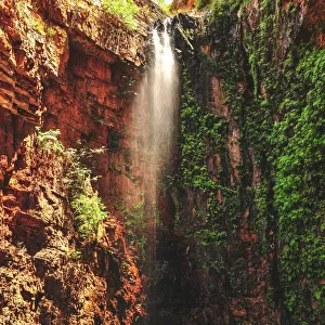
Desert alluvial fan, satellite image
Desert alluvial fan, satellite image. North is at top. Desert areas can sometimes go for years without rain, and then intense storms will cause flooding that fills old dry river beds and forms new ones. The area soon dries out again, leaving these patterns behind. The white, green and blue areas show differing levels of moisture locked into the soil. This alluvial fan is on the southern edge of the Taklamakan Desert in western China. The area shown in this image is around 60 kilometres wide. The image data includes infrared wavelengths, and was obtained on 2 May 2002, using the ASTER sensor on the Terra satellite
Science Photo Library features Science and Medical images including photos and illustrations
Media ID 6359505
© NASA/SCIENCE PHOTO LIBRARY
2000s 2002 Advanced Spaceborne Arid Aster China Chinese Desert Earth Observation Earth Science From Space Hydrology Infra Red Land Physical Geography Reflection Radiometer Riverine Rocky Sandy Satellite Satellite Image Terra Thermal Emission And Alluvial Fan Taklamakan Desert Wadi Xinjiang
FEATURES IN THESE COLLECTIONS
> Animals
> Mammals
> Muridae
> Desert Mouse
> Animals
> Mammals
> Muridae
> Western Mouse
> Arts
> Landscape paintings
> Waterfall and river artworks
> Nature-inspired paintings
> Arts
> Landscape paintings
> Waterfall and river artworks
> River artworks
> Asia
> Related Images
> Europe
> France
> Canton
> Landes
> Science Photo Library
> Aerial and Satellite
> Science
> Space Exploration
> Related Images
> Science
> Space Exploration
> Satellite Imagery
EDITORS COMMENTS
This satellite image showcases a mesmerizing desert alluvial fan, revealing the intricate patterns left behind by intense storms and subsequent drying out. Located on the southern edge of China's vast Taklamakan Desert, this arid landscape stretches approximately 60 kilometers wide. The photograph, taken on May 2nd, 2002, employs infrared wavelengths to capture varying levels of moisture locked within the soil. Desert regions like these can endure years without rainfall until sudden downpours trigger flooding that fills ancient dry river beds while carving new ones. As quickly as the water arrives, it recedes again, leaving behind this awe-inspiring tapestry of white, green, and blue hues representing different degrees of moisture saturation. The image offers a glimpse into Earth's natural hydrological processes and physical geography from a unique perspective - space. Through advanced technology such as ASTER sensors aboard Terra satellites operated by NASA and Japan's Ministry of Economy Trade and Industry (METI), scientists are able to study our planet's ever-changing landscapes with precision. Immerse yourself in this snapshot capturing the raw beauty of nature meeting science. It transports you to an otherworldly realm where sandy desolation intertwines with fleeting moments of life-giving rainwater – an exquisite testament to the delicate balance between earth and sky in one corner of our remarkable planet.
MADE IN THE USA
Safe Shipping with 30 Day Money Back Guarantee
FREE PERSONALISATION*
We are proud to offer a range of customisation features including Personalised Captions, Color Filters and Picture Zoom Tools
SECURE PAYMENTS
We happily accept a wide range of payment options so you can pay for the things you need in the way that is most convenient for you
* Options may vary by product and licensing agreement. Zoomed Pictures can be adjusted in the Cart.